
World Habitat Day: Exploring Nepal’s Urbanization from DEGURBA
As an engineer working with the Department of Urban Development and Building Construction (DUDBC) in Nepal, I have been involved with Habitat Day for a long time. This is the annual observance of World Habitat Day 2024 to celebrate on October 7. This day serves as a pivotal moment to reflect on the state of urban development and the immense challenges we face as a rapidly urbanizing nation. Since its inception in 1986, World Habitat Day has been a global platform for addressing urban issues and Nepal’s active participation since long has brought to light both the opportunities and obstacles that define our urban landscape.
Nepal’s Urbanization: Planner’s Perspective on Rapid Change
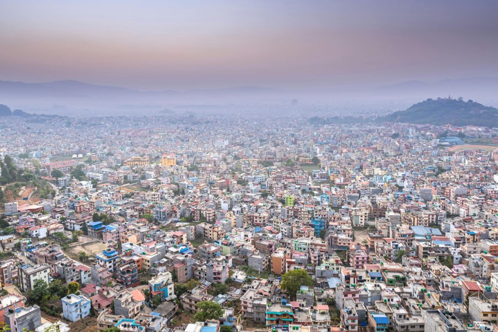
Despite being one of the least urbanized countries globally, Nepal has a surprisingly large proportion of land designated as urban. Municipalities, classified as urban areas, encompass a significant portion of the population. According to the 2078 BS (2021 AD) census, 66.2% of the population resides in municipalities, while 33.8% live in rural municipalities. Comparatively, the 2068 BS (2011 AD) census reported just 17.1% of the population in urban municipalities and 82.9% in rural areas.
The restructuring following the Constitution of Nepal in 2072 BS (2015 AD) dramatically altered this demographic distribution. While the political restructuring was intended to promote urbanization, the resulting data did not accurately reflect the true urban population. To address this, the concept of “Degree of Urbanization in Nepal” (DEGURBA) was introduced, providing a more precise definition of urban areas. You can download the detailed DEGURBA report in PDF here:
Download : नेपालमा ग्रामीण तथा शहरी क्षेत्रको क्षेत्रगत वर्गिकरण (Degree of Urbanization (DUGARBA) in Nepal) (Published by Nepal Statistics Office in 2080 Poush).
Urban areas are characterized by a minimum population density of 3 up to over 15 ppHa and a population exceeding 5,000 with 4-point contiguity.
Peri-urban areas are defined by a density between 3 and 15 ppHa and have no minimum population threshold, exhibiting 8-point contiguity.
Rural clusters are characterized by a density of 3 ppHa or below and a population of no more than 5,000, also demonstrating 8-point contiguity.DEGURBA
What is seen from DEGURBA?
The result from the analysis has been listed in the Annex 1 to Annex 4 of the report, where the Annex 4 only tries to verify the result for four of the local levels charactered by the study.
Annex 1 of the DEGURBA report presents District Level Ward and Population (%) Classification. This annex offers a comprehensive overview of the distribution of wards and population across different districts, categorized by their rural, peri-urban, and urban characteristics. The classification helps to better understand the demographic and spatial dynamics at the district level, serving as a crucial tool for analyzing settlement patterns and urbanization trends across Nepal.

Annex 2 provided insights for Classification of Rural, Peri-Urban and Rural context in factual basis based on the data from Census 2021. Annex 2 of the DEGURBA report provides a classification of wards and population percentages at the municipal level.
For Example : In Baitadi district, there are 84 wards across 10 local levels, 4 Municipalities and 6 Rural Municipalities as : Dasharathchand Municipality (11 wards), Dilasaini Rural Municipality (7 wards), Dogadakedar Rural Municipality (8 wards), Melauli Municipality (9 wards), Pancheshwar Rural Municipality (6 wards), Patan Municipality (10 wards), Purchaudi Municipality (10 wards), Shivnath Rural Municipality (6 wards), Sigas Rural Municipality (9 wards), and Surnaya Rural Municipality (8 wards). According to Annex 2, 81 of these wards are classified as rural, with none designated as peri-urban and only 3 classified as urban – all in Dasharathchand Municipality.
A notable finding is that, despite Baitadi having 4 municipalities, 95.08% of the district’s population resides in rural areas, with 0% classified as peri-urban and only 4.92% living in urban wards. Even at the ward level, this classification emphasizes the overwhelming rural character of the district. If the analysis is extended to actual agglomerations and settlement clusters, the results further underscore the predominantly rural nature of Baitadi.


Cases of Rural – Urban Transition in Nepal
As seen in the aspirational shift during the Municipality Declaration, where 293 municipalities emerged from the original 58, the complexities of rural-urban transition became evident. The conflicts surrounding this transition have reached a critical stage, largely due to the lack of clear, consistent definitions between “urban” and “municipal.” The ground reality of low urbanization highlighted this distinction, as the declaration was more aspirational than an actual reflection of urban development. Consequently, the rural-urban conflict has been widely recognized across various platforms, including academia, where it has been a significant topic of discussion. Below, you will find Urban Planning thesis that not only identify these issues but also propose potential solutions:
Read Also : Rural-Urban Transition Management: A Case of Patan Municipality, Baitadi
The findings from the DEGURBA report underscore critical insights into Nepal’s urbanization, particularly the classification of urban, peri-urban, and rural areas at both district and municipal levels. For instance, as discussed the issue for Baitadi district, the case is no difference for entire 77 districts and 753 Local Levels. The result clearly shows the predominant rural character despite the presence of urban municipalities. The total of 6743 Wards in Nepal are classified as : 3685 Wards having Rural Character (33.2%), 2096 wards as Peri Urban (39.7%) and 962 Wards characterized as Urban (27.1%). The result shows that combined Peri Urban and Urban Population is 66.8% of total population.

The increase in the number of municipalities from 58 to 293 starkly reveals the challenges in accurately distinguishing between urban and rural classifications in Nepal. This surge in municipalities has not necessarily translated to urbanization, as DEGURBA findings illustrate that the rural characteristic remains predominant across the nation. The complexities arising from this rural-urban transition underscore the need for a thorough re-evaluation of urban definitions and strategic planning approaches. Notably, the country comprises 169 local levels in the Himalayan region, 308 in the Hill region, and 276 in the Terai region. DEGURBA’s insights advocate for updated population density thresholds and emphasize the importance of enhanced infrastructure investments across all ecological regions mountains, hills and Terai to foster sustainable urban development and address migration pressures.
As per the census 2021, in terms of Ecological division and demographic distribution, the Mountain region comprises 35% (which was 6.7% in 2011) of the land area but only 5.9% of the population, with 27 municipalities; the Hill region accounts for 42% of the area and houses 40% (which was 42.6% in 2011) of the population, featuring 113 municipalities, including one sub-metropolitan city and three metropolitan cities. The Terai region, covering 19% of the area, supports 49.1% (which was only 46.3% in 2011) of the population and includes 144 municipalities, comprising eight sub-metropolitan and two metropolitan cities. Additionally, the Inner Terai represents 4% area and population 4.9% (which was 4.4% in 2011), with nine municipalities, including two sub-metropolitan and one metropolitan city.
Read Also : SMART CITY: CONTEXT OF NEPAL
Way Forward from DEGURBA
The findings from DEGURBA are particularly valuable for informing urban development and territorial planning, especially in peripheral city areas. Policy recommendations include updating the population density threshold from 10 ppHa to 15 ppHa to reflect current global standards. Additionally, the ward-level rural/urban classification will aid local representatives in strategic planning and development approaches, including land use and taxation. The analysis highlights potential infrastructure deficiencies in the Tarai region, suggesting that development policies should prioritize investments in basic services and focus on building rural-urban linkages to mitigate migration from the Hill and Mountain regions by enhancing essential infrastructure. The finalized result as scrapped from the DEGURBA showed the following trend of Urbanization in Nepal :

Download : नेपालमा ग्रामीण तथा शहरी क्षेत्रको क्षेत्रगत वर्गिकरण (Degree of Urbanization (DUGARBA) in Nepal) (Published by Nepal Statistics Office in 2080 Poush).
Conclusion :
World Habitat Day 2024 serves as a significant occasion for reflecting on urban development challenges in Nepal, especially as the nation grapples with rapid urbanization. As an engineer with the Department of Urban Development and Building Construction (DUDBC), I recognize the importance of this annual observance, which has provided a global platform for discussing urban issues since its inception in 1986. Nepal’s active engagement in these discussions has illuminated both the opportunities and obstacles shaping our urban landscape. Despite being one of the least urbanized countries, a considerable portion of Nepal’s land is classified as urban. Recent census data reveals a dramatic demographic shift, with 66.2% of the population now residing in municipalities, compared to just 17.1% a decade ago. This shift was catalyzed by the 2015 Constitution, which introduced the “Degree of Urbanization in Nepal” (DEGURBA), refining our understanding of urban areas through precise definitions based on population density, contiguity, and demographic characteristics.
In conclusion, the findings from DEGURBA are instrumental in guiding future urban planning and policy formulation in Nepal. They ensure that urban development reflects the country’s true demographic realities across all regions, paving the way for a more balanced, sustainable and inclusive future.


3 Comments